

Examples of Landforms
Landforms are natural physical features of the Earth’s surface. As an element of topography, a landform is defined by its shape, location, and how it was formed.
Aeolian Landforms
Aeolian landforms are formed by either the erosive or constructive action of the wind. As the wind erodes the land it has the effect of sandblasting the surface, leaving rock surfaces such as those found in the desert.
Examples are:
- Barchan – A convex-shaped sand dune with a gentle slope up the side of the wind direction and a 30-35 degree slip face that faces away from the wind
- Blowout – A small hollow
- Desert pavement – A sheet-like surface of rock
- Desert varnish – A dark stain on the surfaces of desert rocks
- Dune – A hill or mountain of sand
- Dreikanter – A three-faced weathered rock
- Erg – A sand covered desert
- Loess – An accumulation of sediment or silt that are joined together by calcium carbonate
- Dry lake – A waterless lakebed, typically covered in fine-grained rocks that contain salt
- Sandhill – A sandy or low-vegetation hill area that receives minimal rainfall and has trouble retaining the water.
- Ventifact – Rocks that have been cut and polished by the wind
- Yardang – Very large or very long, streamlined, sculpted forms caused by wind erosion
Coastal and Oceanic Landforms
- Abyssal fan – An underwater deposit of sediment formed by water currents
- Abyssal plain – A flat, smooth underwater surface that covers over 50% of the Earth’s surface. It forms the bottom of the continental rise and the top of the oceanic trench
- Archipelago – A group of islands
- Atoll – A ring-shaped coral reef
- Arch – A rock formation with an opening
- Ayre – A narrow beach across the ends of a shallow bay
- Barrier bar and barrier island – A flat formation of sand that is parallel to the coast
- Bay and gulf – A body of water connected to an ocean but surrounded on most sides by land
- Beach and raised beach – The land along the edge of a body of water, consisting of loose rocks or sand.
- Beach cusps – Sediment in an arc shape on the shore, caused by the wave action
- Beach ridge – A ridge running parallel to the water’s edge, caused by wave action
- Bight – A recessed area in a coastline
- Blowhole – A hole in the end of a sea cave
- Channel – A narrow body of water
- Cape – A portion of land that extends into the sea or ocean
- Calanque – A steep cove
- Cliff – A vertical wall of rock
- Coast – Where the water meets the land
- Continental shelf – The extended edge of each continent which is underwater
- Coral reef – Underwater formations of calcium carbonate
- Cove – A small bay
- Cuspate foreland – An accumulation of sand and gravel forming a land body that extends like a “finger” into the body of water
- Dune system – Groups of sand dunes
- Estuary – A semi-enclosed body of water with a connection to the sea and with at least one inbound source of water
- Firth – A large bay
- Fjard – A short, shallow and broad fjord
- Fjord – a long narrow inlet with steep cliffs
- Headland – A point of land that extends into a body of water and has a steep drop
- Inlet – A connection between a bay and the ocean
- Island, islet – A portion of land that is surrounded on all sides by water
- Islet – A rock that is surrounded on all sides by water
- Isthmus – A narrow strip of land with water on each side
- Lagoon – A shallow body of water
- Machair – The grassy fields that are inland from a dune ridge
- Marine terrace – A flat, often slightly inclined, surface with a slight slope on the water side and a steeper slope on the land side
- Mid-ocean ridge – An underwater mountain system
- Ocean – A body of salt water
- Oceanic basin – A basin that is below sea level
- Oceanic plateau – A flat rock formation that is above the continental slope
- Oceanic trench – A long, narrow opening on the ocean floor
- Peninsula – A piece of land that has water on three sides
- Ria – A river valley that is open to the sea
- River delta – A deposit of sediment at the mouth of a river where it flows into a larger body of water
- Salt marsh – An area between the saltwater sea and a piece of land that is flooded by salt water
- Sea – The salty water that covers 70% of the Earth
- Sea cave – A cave at the edge of the sea that is formed by wave action
- Seamount – An underwater mountain
- Shoal – A sandbar
- Shore – Where the water meets the land
- Sound – A large ocean channel between two bodies of land
- Spit – A piece of land that extends into water
- Strait – A narrow waterway that connects two larger bodies of water
- Strandflat – The low land on the actic and antarctic coasts
- Submarine canyon – A steep valley in the sea floor
- Surge channel – A very narrow opening in the rocks of the shoreline
- Volcanic arc – A chain of volcanoes positioned in a slightly curved layout
- Wave cut platform – The flat area at the base of a cliff created by the waves
Landforms Produced by Erosion and Weathering
- Badlands- A dry terrain with steep slopes and little or no vegetation
- Butte- An isolated hill that typically has a flat stop and steep sides
- Canyon- A deep ravine between two cliffs or encasements, like the Grand Canyon
- Cave- An underground space created by the weathering of rocks that is enclosed and large enough to enter
- Cliff- An area with a steep drop-off, usually formed by erosion and near rock exposures
- Cuesta- A hill or a ridge with a gentle slope
- Gulch- A deep valley that has generally been formed by land erosion
- Gully- A ditch or valley created by erosion
- Hogback- A narrow ridge of hills with steep slopes and a narrow crest. The slopes are usually close to equal on both sides
- Hoodoo- A tall thin rock formation protruding from the bottom of a badland
- Lavaka- A hole in the side of a hill caused by erosion
- Mesa- A tableland, or an elevated area with a flat top and steep cliff-like sides
- Mountain pass – A path through a mountain range over a low point in a ridge
- Plain – A large area that is flat or gently rolling, usually low in elevation
- Plateau – An area that is high in elevation and basically flat
- Ravine – Formed by running water, a ravine is smaller than a canyon and is steep and deep
- Ridge – A chain of hills or mountains
- Rock shelter – An cave-like opening at the base of a cliff
- Scree – A collection of broken rocks at the base of a mountain
- Strath – A wide shallow river valley
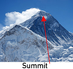
- Summit – The highest point on a hill or mountain
- Valley – A low area between hills or mountains
Volcanic Land Forms
- Caldera – A crater formed by the collapse of land after an eruption
- Complex volcano – A volcano with more than one feature because of multiple vents
- Crater lake – A lake that formed inside a caldera
- Cryovolcano – Erupts water, methane or ammonia rather than lava
- Geyser – A hole in the ground where water and steam shoots out
- Guyot – A volcano under the water with a flat top
- Lava dome – A mound that forms by lava that does not easily flow away
- Lava flow – Lava that is moving
- Lava plain – A large area of lava flows
- Lava spine – A vertical formation formed by slow-moving lava
- Maar – A shallow volcanic crater caused by an explosion of groundwater water contacting magma or lava
- Malpais – An area of eroded volcanic rocks
- Mid-ocean ridge – An underwater chain of mountains where upwelling magma forms new crust
- Mud volcano – A mound formed when gas comes through a vent and causes mud to boil
- Oceanic trench – A very long steep depression in the ocean floor
- Pit crater – Formed by a collapse of the surface rather than an eruption
- Sand volcano – Made of ejected sand
- Shield volcano – A large domed volcano with gently sloping sides
- Stratovolcano – A conical volcano with steep sides
- Subglacial mound – Formed by eruption under a glacier
- Submarine volcano – An underwater vent where magma may erupt
- Supervolcano – A volcano that may eject a volume of more than 240 cubic miles
- Tuya – A volcano with steep sides and a flat top made by lava erupting through a glacier
- Vent – An opening through which lava, ash and gas can escape
- Volcanic dam – A natural dam made of lava or other volcanic material and debris
- Volcanic field – An area with a cluster of volcanoes
- Volcanic island – A volcano under the ocean that grew until it broke the surface of the water
- Volcanic plateau – A flat surface formed by many volcanic eruptions
- Volcanic plug – Forms when magma cools and hardens within a vent
- Volcano – A mountain formed by an eruption of lava and ash
These different examples of landforms highlight the many types of formations caused by wind and water.